


BENTON TWP Voting District, Taylor County, Iowa
About
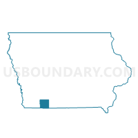
Outline

Summary
| Unique Area Identifier | 583553 |
| Name | BENTON TWP Voting District |
| County | Taylor County |
| State | Iowa |
| Area (square miles) | 24.43 |
| Land Area (square miles) | 24.12 |
| Water Area (square miles) | 0.31 |
| % of Land Area | 98.72 |
| % of Water Area | 1.28 |
| Latitude of the Internal Point | 40.69350420 |
| Longtitude of the Internal Point | -94.75470870 |
Maps


Graphs
Select a template below for downloading or customizing gragh for BENTON TWP Voting District, Taylor County, Iowa


Neighbors
Neighoring Voting District (by Name) Neighboring Voting District on the Map
- BEDFORD Voting District, Taylor County, IA
- BEDFORD TWP W/O BEDFORD Voting District, Taylor County, IA
- CLAYTON TWP Voting District, Taylor County, IA
- MARSHALL TWP Voting District, Taylor County, IA
- MASON TWP Voting District, Taylor County, IA
- POLK TWP Voting District, Taylor County, IA
- ROSS TWP Voting District, Taylor County, IA
- WASHINGTON TWP Voting District, Taylor County, IA
Top 10 Neighboring County Subdivision (by Population) Neighboring County Subdivision on the Map
- Bedford township, Taylor County, IA (1,517)
- Washington township, Taylor County, IA (353)
- Marshall township, Taylor County, IA (214)
- Ross township, Taylor County, IA (184)
- Mason township, Taylor County, IA (164)
- Benton township, Taylor County, IA (146)
- Polk township, Taylor County, IA (127)
- Clayton township, Taylor County, IA (97)